Romania is situated in Central Europe, in the northern part of the Balkan peninsula and its territory is marked by the Carpathian Mountains, the Danube and the Black Sea. Climatic conditions are somewhat modified by the countrys varied relief. Romania lies between 43 37 07 and 48 15 06 Latitude North and 20 15 44 and 29 41 24 Longitude East. Parallel 45 Latitude North (midway between the Equator and the North Pole) crosses Romania 70 km north of its capital and meridian 25 Longitude East (midway between the Atlantic coast and the Urals) runs 90 km west of Bucharest. The climate of Romania is a mild with four seasons clearly distinguished.
Because of its position on the southeastern region of the European continent and the very changeable configuration of the baric field makes the territory of Romania accessible to a very large scale of air masses, adding to the climate the transition character: The continental character of the Romanian climate, with an important range of temperature both in the diurnal and in the annual cycles, is related to the country position on the continent (at 2 000 km from the Atlantic Ocean, at 1 000 km from the Baltic Sea, and at 400 km from the Adriatic Sea) and also to the shield effect of the mountains.
The average yearly temperature is 8 - 110 C in the agricultural area and decreases to -20 C on the summit of the Carphatians. The frost-free period varies from 200 - 240 to 100 - 120 days. In the agricultural area average precipitation varies between 400 and 800 mm/year, while in the mountain area precipitation rises to over 1200 mm/year. The extension of the territory over almost 50 in latitude leads to quite important differences in temperature between the south and the north of the country for the air temperature, while the 100 extension in longitude leads to only reduced such differences. If the mean annual temperature in the south of the country is ca. 110 C, in the north of the country at the same altitude the values for the same parameter are lower with ca. 30 C. Between the west side and the east side of the country the temperature difference is only ca. 10 C (100 C in the west, 110 C in the east). The differences of the precipitation are more important, from about 700 mm in west side of the country to less than 400 mm in the east side.
The altitude imposes differences up to 140 C for the mean annual temperature between south low-level extremity of the country (11. 00 C) and the Varfu (point, peak, top) Omu (-2, 70 C), the highest weather station in the Romania.
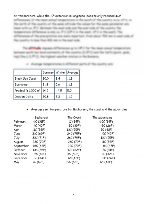
Avarage temperatures in different parts of the country are: Average year temperature for Bucharest, the coast and the Mountains Bucharest The Coast The Mountains February -1C (31F) 1C (34F) -10C (14F) March 4C (40F) 3C (39F) -3C (26F) April 11C (52F) 13C (55F) 5C (41F) June 21C (69F) 24C (75F) 9C (49F) July 23C (71F) 26C (79F) 13C (55F) August 22C (70F) 26C (79F) 11C (52F) September ...
Documentul este oferit gratuit,
trebuie doar să te autentifici in contul tău.