Extras din referat
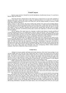
Grand Canyon
Immense gorge cut by the Colorado River into the high plateaus of northwestern Arizona, U.S., noted for its fantastic shapes and coloration.
The broad, intricately sculptured chasm of the Grand Canyon contains between its outer walls a multitude of imposing peaks, buttes, canyons, and ravines. It ranges in width from about 0.1 to 18 miles (0.2 to 29 km) and extends in a winding course from the mouth of the Paria River, near the northern boundary of Arizona, to Grand Wash Cliffs, near the Nevada line, a
distance of about 277 miles (446 km). The canyon includes many tributary side canyons and surrounding plateaus. The deepest and most impressively beautiful section, 56 miles (90 km) long, is within Grand Canyon National Park, which encompasses the river's length from Lake Powell to Lake Mead. In its general colour, the canyon is red, but each stratum or group of strata has a distinctive hue--buff and gray, delicate green and pink, and, in its depths, brown, slate-gray, and violet. At 8,200 feet (2,500 m) above sea level, the North Rim is 1,200 feet (350 m) higher than the South Rim.
The first sighting of the Grand Canyon by a European is credited to the Francisco Coronado expedition of 1540 and subsequent discovery to two Spanish priests, Francisco Garcés and Silvestre Vélez de Escalante, in 1776. In the early 1800s trappers examined it, and sundry government expeditions exploring and mapping the West began to record information about the canyon. By the 1870s, following the exploration of John Wesley Powell and others, extensive reports on the geography, geology, botany, and ethnology of the area were being published.
Grand Canyon National Park, now containing 1,904 square miles (4,931 square km), was created in 1919. Its area was greatly enlarged in 1975 by the addition of the former Grand Canyon National Monument and Marble Canyon National Monument and by portions of Glen Canyon National Recreation Area, as well as other adjoining lands. The North and South rims are connected by a 215-mile- (346-kilometre-) long paved road and by a transcanyon trail. Scenic drives and trails lead to all important features. Mule-pack trips down the canyon and rides down the river in rafts and power-driven craft are intensively sought-after ways of viewing and experiencing the vast beauty of the canyon. Many pueblo and cliff-dweller ruins, with accompanying artifacts, indicate prehistoric occupation. There are five Indian tribes living on nearby reservations.
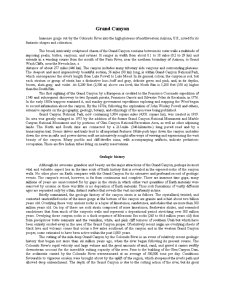
Geologic history
Although its awesome grandeur and beauty are the major attractions of the Grand Canyon, perhaps its most vital and valuable aspect lies in the time scale of Earth history that is revealed in the exposed rocks of the canyon walls. No other place on Earth compares with the Grand Canyon for its extensive and profound record of geologic events. The canyon's record, however, is far from continuous and complete. There are immense time gaps; many millions of years are unaccounted for by gaps in the strata in which either vast quantities of Earth materials were removed by erosion or there was little or no deposition of Earth materials. Thus rock formations of vastly different ages are separated only by a thin, distinct surface that reveals the vast unconformity in time.
Briefly summarized, the geologic history of the canyon strata is as follows. The crystallized, twisted, and contorted unstratified rocks of the inner gorge at the bottom of the canyon are granite and schist about two billion years old. Overlying these very ancient rocks is a layer of limestones, sandstones, and shales that are more than 500 million years old. On top of these are rock strata composed of more limestones, freshwater shales, and cemented sandstones that form much of the canyon's walls and represent a depositional period stretching over 300 million years. Overlying these canyon rocks is a thick sequence of Mesozoic Era rocks (245 to 66.4 million years old) that form precipitous butte remnants and the vermilion, white, and pink cliff terraces of southern Utah but which have been entirely eroded away in the area of the Grand Canyon proper. Of relatively recent origin are overlying sheets of black lava and volcanic cones that occur a few miles southeast of the canyon and in the western Grand Canyon proper, some estimated to have been active within the past 1,000 years.
The cutting of the mile-deep Grand Canyon by the Colorado River is an event of relatively recent geologic history that began not more than six million years ago, when the river began following its present course. The Colorado River's rapid velocity and large volume and the great amounts of mud, sand, and gravel it carries swiftly downstream account for the incredible cutting capacity of the river. Prior to the building of the Glen Canyon Dam, the sediments carried by the Colorado River weremeasured at an average of 500,000 tons per day. Conditions favourable to vigorous erosion were brought about by the uplift of the region, which steepened the river's path and allowed deep entrenchment. The depth of the Grand Canyon is due to the cutting action of the river, but its great width is explained by rain, wind, temperature, and chemical erosion, helped by the rapid wear of soft rocks, all of which steadily widened it. Amazingly, the canyon was cut by a reverse process, for the river remained in place and cut through the rocks as the land moved slowly upward against it. Only thus can be explained the canyon's east-to-west course across a south-facing slope and the presence of plateaus that stand across the river's course without having deflected it.
The most significant aspect of the environment that is responsible for the canyon is frequently overlooked or not recognized. Were it not for the arid climate in the surrounding area, there would be no Grand Canyon. Slope wash from rainfall would have removed the canyon walls, the stairstep topography would long ago have been excavated, the distinctive sculpturing and the multicoloured rock structures could not exist, the Painted Desert would be gone, and the picturesque Monument Valley would have only a few rounded hillocks.
Preview document
Conținut arhivă zip
- Grand Canyon.doc
Te-ar putea interesa și

Introducere Lucrarea de faţă, cu titlul: „Analiza economică şi socială comparativă între SUA şi China”, prezintă analiza comparativă între Statele...

ECOTURISM “Ariile naturale protejate reprezinta principala destinatie ecoturistica la nivel planetar deoarece aceasta asigura practicarea unui...

CAPITOLUL I 1. Introducere În secolul XIX, STATELE UNITE ale AMERICII s-a afirmat ca mare putere agricolă. Tutunul, bumbacul, cerealele,...

Impactul uman asupra naturii se resimte prin disparitia unor specii de plante si animale.Dintre speciile care au populat pamantul in epoca istorica...

UNITATEA ȘCOLARĂ: Școala Gimnazială „Milivoi Trifunschi” Sânpetru Mare DATA: 19.02.2020 CLASA: a VII-a ARIA CURRICULARĂ: Om și societate....

Mots-clé:forme,paysage,cols,quais,gorges,canyons,grotte. Le relief est la ressource attractive la plus riche et variée du globe.Il constitue le...

Theme No.1. The Subject of Study of The Tourist Resources Management 1.INTRODUCTORY NOTIONS. LEARNING OBJECTIVES: LEARN ABOUT THE HISTORY OF...

Caracteristici generale Raftingul reprezintă activități recreative în aer liber care utilizează o plută gonflabilă pentru a naviga pe un râu sau...