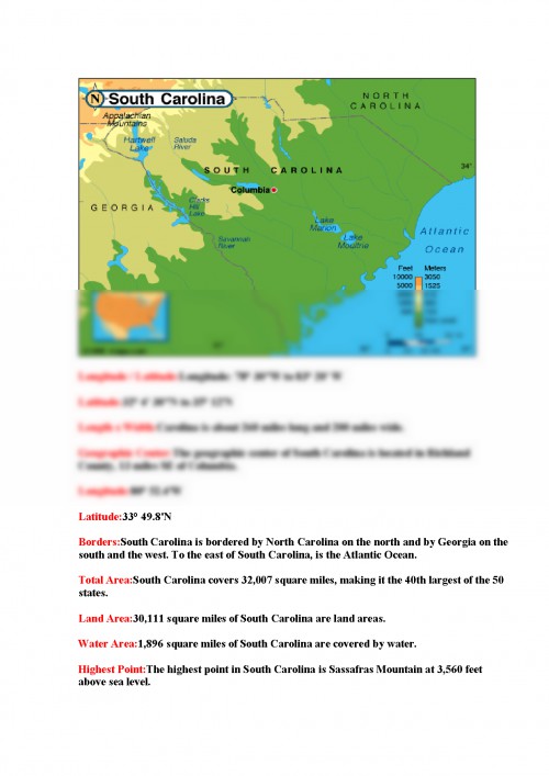

Geographic Center: The geographic center of South Carolina is located in Richland County, 13 miles SE of Columbia. Borders: South Carolina is bordered by North Carolina on the north and by Georgia on the south and the west. To the east of South Carolina, is the Atlantic Ocean.
Highest Point: The highest point in South Carolina is Sassafras Mountain at 3, 560 feet above sea level. Lowest Point: The lowest point in South Carolina is sea level, where South Carolina meets the Atlantic Ocean.
Mean Elevation: The Mean Elevation of the state of South Carolina is 350 feet above sea level. Major Rivers: Edisto River, Pee Dee River, Santee River, Savannah River Major Lakes: Lake Greenwood, Lake Marion, Lake Moultrie The Land: Three geographic land areas define South Carolina; the Atlantic Coastal Plain, the Piedmont, and the Blue Ridge region. South Carolinians simplify this somewhat by referring to the eastern Atlantic Coastal Plain as the South Carolina Low Country and the Piedmont and the Blue Ridge region as Up Country. Two thirds of South Carolina is covered by the Atlantic Coastal Plain, from the Atlantic Ocean extending to the west. The land rises gradually from the southeast to the northwest.
An area of the Atlantic Coastal Plain, defined as extending from the coast about 70 miles inland, is referred to as the Outer Coastal Plain.
This area is quite flat. Many rivers can be found in the Outer Coastal Plain with swamps near the coast that extend inland along the rivers. An area called the Inner Coastal Plain consists of rolling hills. This is where South Carolinas most fertile soils are found.
In the central Atlantic Coastal Plain is an area of forested land called the Pine Barrens. On the western edge of the Atlantic Coastal Plain, running from the southwest to the northeast, is a line of sand hills. These sand hills may have once marked the eastern coast of South Carolina suggesting that the entire Atlantic Coastal Plain may have once been under water.
To the northwest of the Atlantic Coastal Plain is the Piedmont. The Piedmont is marked by higher elevations, from 400 to 1, 200 feet above sea level and reaching 1, 400 above sea level on its western edge. The landscape consists of rolling hills; gentler in the east and more hilly to the west and northwest.
The border between the Piedmont region and the Atlantic Coastal Plain is called the Fall Line to mark the line where the upland rivers fall to the lower Atlantic Coastal Plain.
The Blue Ridge covers the northwestern corner of South Carolina. Part of the larger Blue Ridge that extends from southern Pennsylvania south to Georgia, the South Carolina Blue Ridge Mountains are lower and less rugged than the mountains in North Carolina. The forest covered Blue Ridge Mountains of South Carolina rarely exceed 3, 000 feet above sea level. The highest point in South Carolina, Sassafras Mountain, reaches 3, 554 feet into the sky.
(South Carolina Close-up) Climate (F) ...
Documentul este oferit gratuit,
trebuie doar să te autentifici in contul tău.